
Hey friends,
Those of you who’ve followed me for a while know that in addition to travel, I have another passion: climbing. (For more context, see one of my favorite essays I’ve ever written: ‘Work the Problem.”) The “Pieces of Life” feed is a pretty solid example of this: it alternates between climbing pictures and travel pictures. The two don’t mix, they come in blocks. A month of climbing photos, then a few months of travel photos. Then back to the climbing. Then more travel. Etc.
The night before I left Colombia, I met an American expat for drinks. Happy for a friend, he kept buying me rounds. Uneager to leave Colombia, I kept accepting. Together, over the course of what was supposed to be just a quick get-to-know-you afternoon, we drank 26 beers. Our pyramid of empties filled the tiny table.
I traveled home the next day: 12 hours, three airports, one hangover. I arrived in Colorado late on a Saturday night. The next morning, Sunday, I was in Boulder Canyon, climbing. Leading 5.10d and 5.11a, although certainly not elegantly. Most people wouldn’t do that.
I wasn’t speaking Spanish, but I was speaking a language I loved — climbers have a language and a diction all their own. Kneebars, cams, handjams, crimps, onsight… words I loved hearing almost as much as chevere, súper, and ciao.
Ever since returning home from Colombia, I’ve been climbing a lot. I find this is the most effective way to fight the post-travel depression that always sets in when I return from an extended jaunt abroad. Luckily for me, home is Colorado, where amazing climbing literally comes at you around every corner.
While I’ve been doing a ton of climbing, I realized I haven’t written much about it. So today, I figured I’d give it a go.
I’ve been home for a month now, and I’ve been climbing over a dozen times with half a dozen partners. But the person I’ve been climbing the most with is Meg. Meg’s also a blogger: you can find her climbing blog here, at Meg of the Mountain. I encourage you to poke around. Meg’s more of a mountain person than a rock climbing person, as she reminds me every time I drag her onto pure rock climbs. She rarely climbs harder than 5.7, a grade that I could usually free-solo (climb without ropes) pretty comfortably.

Meg really likes to ice climb, but thank god it’s summer, so she can’t force me on to any ice just right now.
But since my strong partner, Shawn, decided to move to Hungary, I’ve been climbing lot with Meg (For an account of my last adventure with Shawn, see: An Average Climber’s International Trip or The Best Restaurant in Budapest). This means I’ve been climbing a lot of easier stuff, learning technical and mountain skills, instead of pushing grades on sport climbing cliffs.
In the year since I’ve known her, Meg’s taught me to ice climb, showed me how to use crampons and an ice ax on snow, and given me a lot of experience at dealing with and escaping from less-than-ideal situations in the mountains and on the rock. We’ve developed a good chemistry, a good sense of each other, and a solid relationship as climbing partners.

Getting along great at the base of Mr. Natural, (5.8) in Eldorado Canyon
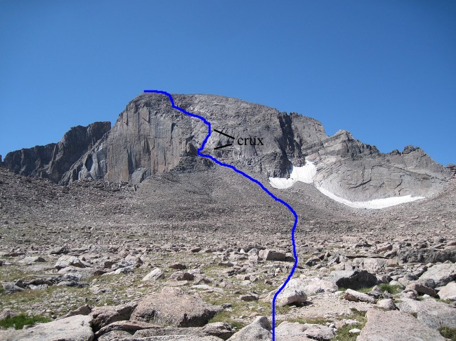
This Friday (7/7/2017), we put it all together with a serious attempt on the Cables Route (North Face) of Long’s Peak.
Long’s Peak is one of Colorado’s most popular fourteeners (14,000+ foot [4,267 meters] tall mountains). The mountain is strangely technical for its popularity—each year people die or are rescued off the mountain for underestimating the length, exposure, or conditions of the mountain.
The most common route up Long’s is called the Keyhole Route: a rite of passage for most Coloradans, everyone knows the route, even if they haven’t hiked it themselves. The route is classified as Class III, which in mountain terms means it’s kind of like an extreme hike. It’s not a simple walk, but it isn’t a rock climb.
I had a few goals for this year. One of them was to learn Spanish. The other was to climb Long’s Peak.
I’d never been on Long’s, but after five years climbing, I knew there were several technical routes on the peak that were within my abilities. After years of short, low-elevation rock climbs, and only hiking to the tops of peaks, I was getting the itch to try my hand climbing in the alpine.
Meg and I had tried twice to climb the Bell Cord Couloir on the Maroon Bells, a steep snow route that splits the peaks, but never made it very far on either attempt. With neither of us eager to drive five hours back to Aspen for a third time, and since Long’s Peak was one of the seven mountains Meg still needed on her quest to summit every one of Colorado’s 14ers, we decided to go after Long’s. In pursuit of my goal, we selected the Cables Route, which involves some fifth-class rock climbing, over the Keyhole route, which is more of an exposed hike (Third-class). The Cables Route also has the advantage of being about 3 miles shorter, roundtrip, than the Keyhole route.
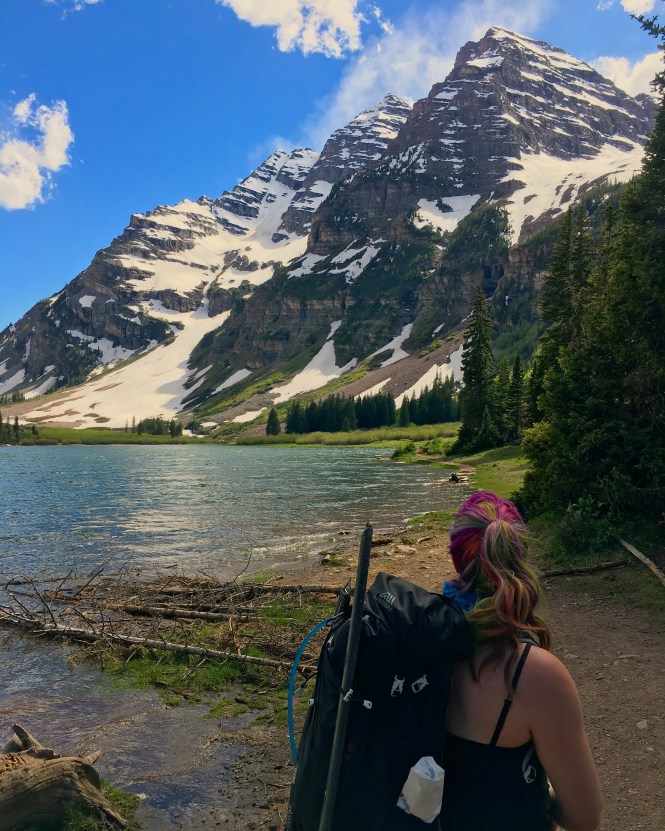
Meg’s colorful hair makes her a great person to foreground in your photos. (Crater Lake, Aspen, Colorado). The Bell Cord would start at that big snow apron, then go up and to the right.
And despite summiting 51 of Colorado’s 58 fourteeners, Meg had never used a rope on a mountain. So the Cables Route, with a pitch of fifth-class climbing, would be a first for both of us.
I arrived at Meg’s home in Lafayette at around 11 p.m. on Thursday night, and after a few stops for food and to borrow a second pair of microspikes, we were at the trailhead around 1:30 a.m. Both of us were running on little or no sleep, as we’d made a somewhat last-minute decision to climb the mountain.
I chugged some green tea from my thermos, hoping to get the little boost I needed to last out the night. We changed our clothes and geared up at the car — I took the rock rack and the rope, which added quite a bit of weight to my pack. At 9,500 feet, it wasn’t bad, but I knew it would only feel heavier as we got to higher and higher elevations.
With a long hike by headlamp ahead of us, we both agreed to throw in some headphones and listen to music for a while. This helped a few featureless hours pass relatively quickly.

Hiking by headlamp — not super photogenic.
We hit treeline around 3:30 a.m., where we sat for a while and ate a sandwich. Light was just starting to creep into the sky, and we worried we might be too early for our route — we didn’t want to encounter ice on the technical rock climbing section, which meant we needed to wait for the sun to melt it out.
We were drastically overestimating our abilities, and underestimating the size of the mountain.
Around this time, a few other parties started passing us. They were all bound for the Keyhole Route, as no one else we encountered had a rope. Most carried ice axes, but here and there a family or a trailrunner did not.
After a few more hours we reached the infamous Boulder Field: a huge, mile-wide bowl full of scattered boulders. Some of the less ambitious hikers will camp in the Boulder Field before going up the Keyhole. Meg and I both agreed it seemed like an unpleasant place to camp — vulnerable to high alpine storms and winds screaming down from almost all sides.
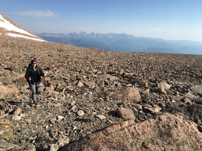
Looking back to the entrance to the Boulder Field
We hiked on to the campsites, where I used the (disgusting) toilets, and Meg made conversation with a few campers. We got beta (information) on our route from a kind old man, a real old-schooler, who remembered climbing the Cables route with a ‘chest belay,’ a relic from the pioneering days of climbing, and painfully outdated these days.
Here, we divulged from the crowd: the trail to the keyhole continued to the right, but our climb lay to the left. We started picking our way across the huge boulder field. Without a trail, we simply followed our noses, aiming for a point on the left side of the peak, near the huge distinctive face known as “The Diamond.”
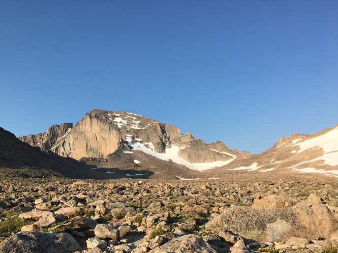
The Diamond on the left. The Cables Route climbs to the summit from the highest point of the leftmost (lower) snowfield. The Keyhole is visible near the low point of the valley on the right.
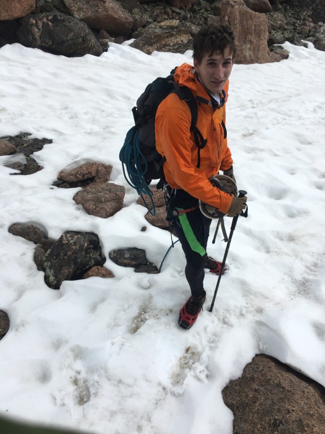
We crossed the rocks fairly quickly. Since we were climbing in early July, a decent-sized snowfield protected the approach to our rock climb. We stopped at the base of the snowfield and put on our microspikes. Meg had brought an ice-ax, but I had only a pair of cheap trekking poles. They would work well enough for regular placements, but if I happened to slip, self-arrest using the poles would be impossible.
As we sat and geared up, we watched a pair of climbers coming down the route we wanted to go up. It was 9:30 or 10, and they were coming down already.
“They just climbed the Diamond,” Meg said confidently.
The Diamond seen from lower down on the mountain. It’s the looming face on the right. 1,000 vertical feet from top to bottom.
The Diamond is an impressive, 1,000 foot face that defines Long’s Peak. It’s quite popular with rock climbers, and for good reason: the formation is huge, incredibly aesthetic, and every route on it goes at 5.10 or harder. These guys had been up it, summited, and were coming down our route. As we watched them further, we realized that they weren’t even rappelling — they were downclimbing, with no rope at all. They reached the bottom of the route, the traversed over to Chasm View, a small ledge with vertiginous exposure and great views of the Diamond. They whooped, waved, and jumped up and down, presumably signaling to friends still on the face.
“They make me nervous,” said Meg as we began our slog up the snowfield. The snow was mushy from the morning sun — there definitely wasn’t going to be ice on our route when we arrived

At the base of the snow climb, with the Boulder Field in the background
We continued up: walking straight up the steepening snowfield, kicking steps and using our microspikes for traction. In lieu of an ice-ax, I jammed my trekking poles deep into the snow with every step. When I slipped, the poles held, arresting my fall. As we kept going, the climbers above us started coming down.
They kicked the snow a little bit. “Perfect glissading conditions,” one said to the other. Meg, having previously assessed the slope as “shit for glissading,” snorted. The pair weren’t even carrying ice axes. With big smiles on their faces, they began galloping down the slope: a running glissade. I’d read about the technique in The Freedom of the Hills, but never actually seen anyone do it.
The pair stopped when they reached us, to exchange a few casual words. Having a good day? All that. The face of one of the climber’s looked familiar. Is that? I thought… I looked down at his hands and saw he had a finger missing above the knuckle.
- It was Tommy Caldwell, a professional climber who made national news a few years back for establishing the first free ascent of the Dawn Wall in Yosemite (which I wrote about here, back when this was a very different sort of blog). I didn’t recognize his partner. We asked them what they’d climbed. “Oh, just the Casual Route,” Caldwell answered. “Have a good one!” he said, as they galloped away down the snowfield. It sure didn’t look like they had a rope with them.

He lost the finger in a tablesaw accident, and is STILL one of the world’s best rock climbers.
That’s the sort of thing that can happen in Colorado.
Meg and I geeked out a bit as we finished climbing the snowfield. How cool was that?! I was feeling a little anxious about our time now, seeing a party already descending. It had been Tommy Caldwell, a pro climber, which eased my shame a little bit, but still. I checked my watch: 10:30. We hadn’t even started up the technical climbing, which meant no matter how you looked at it, we were running late.
The rule with Colorado 14ers, in summer, is to be off the peaks by 12:00. This is because Colorado is infamous for early afternoon thunderstorms. The last place you want to be in a lightning storm is standing on top of a 14,000 peak. Especially when you’re carrying an ice ax and a bunch of metal rock climbing equipment on your harness. You’re basically a human lightning rod. We kept on slogging up the snow.

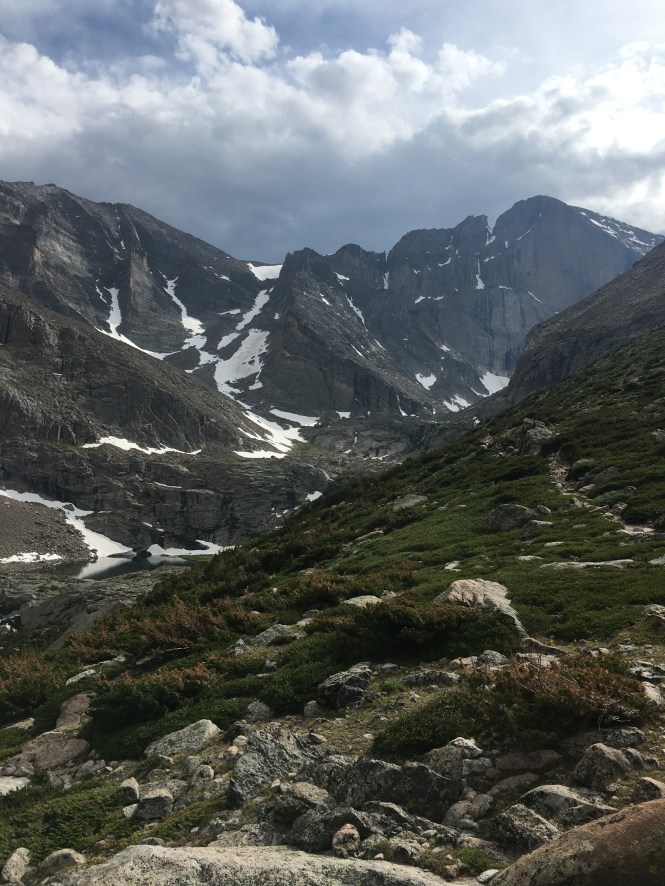
Chasm View visible down and to the right — from here on, the exposure gets huge.
We reached the base of our route around 11 a.m. It was easy to identify thanks to the huge metal eyebolt sticking out of the wall about twenty feet from the ground.
The route is called the “Cables Route” because back in the day, this was the standard ascent up Long’s. The Park Service had installed a giant guiding cable that hikers could use to ascend the technical section, similar to the cables on Half Dome, or the one at Angel’s Landing in Zion. Unfortunately, this huge metal cable also had the tendency of attracting lighting, so it was removed at some point. The eyebolts which used to anchor the cable still remain though, and they make excellent rappel anchors for roped climbers looking to ascend or descend the route.

The route was absolutely gushing water, as the high-elevation snowfields melted off, right down our climb.
Feeling the press of time, I geared up at the base of the route while waiting for Meg to catch up. I surveyed conditions: the route looked easy enough, but it was weeping water almost everywhere. It was going to be cold and slippery. I opted to keep my gloves and microspikes on for the climb. The spikes would be more useful than rubber on the wet rock, and I didn’t forsee any spots where I’d need real finger dexterity.
I built Meg an anchor out of some of the rock climbing gear we’d brought, and I belayed her up the final few moves to the belay ledge at the bottom of the climb. We both ate something, and I started up the technical climbing. Here, we stashed the camera in the interest of efficiency.
About ¾ of the way up the pitch, we heard a thunderclap. I tried to yell down to Meg, but the water running down the climb, combined with our elevation difference, made having a coherent conversation very difficult. I stuck a gold number 2 cam into the wall, clipped my rope through it, and called for a lower. She brought me down to a spot where we could hear each other, and we had a brief discussion about the weather.
We both knew we should bail here. That’s common mountain sense, and Meg and I both had the experience to know so.

This is NOT the type of weather you want to see while you’re on top of a mountain
But after ten hours hiking in, anticipating your summit, it can be hard to turn back at just a suggestion of poor weather. And in all other directions, things did look clear — although the looming face we were climbing blocked our view to the West, a fact which concerned both of us, but remained unvoiced.
The storm we’d heard was dropping rain on the Front Range — I could see it from the wall. It didn’t appear to be moving in our direction. We made the decision to keep climbing. I rocketed up to the top of the pitch, established a belay, and began bringing Meg up. While I hauled in slack with my guide-mode belay device, I kept my gaze fixed on the sky.
Which direction was the wind moving, and what was it going to bring our way? The storms from the Front Range definitely weren’t heading for us. It was clear and sunny to the Southwest, but it looked a little dark to the North. The wind seemed to be moving Southwest, but then it changed.
Meg made quick work of the pitch, despite the fact that we were climbing at probably 13,900 feet in altitude or so. As she topped out, we heard another thunderclap. We looked at each other. The path from here was supposed to be cairned, third-class. A lot easier than the snow and rock we’d just climbed to get here. But the weather was threatening. The textbook decision was to go down. We were at the top of the eyebolts — a rappel would be easy and quick to do. A brief discussion ensued.
Let’s gun for it.
We left the rope at the eyebolt. This took a lot of weight off my shoulders, and established an easy visual landmark for when we needed to descend. We started following a loose trail, marked by occasional cairns, towards the summit. The weather continued worsening. We both felt the urgency of moving quickly. The sooner we were off this rock, the better.
The trail began moving left. We were now directly above the Diamond. Maybe ten to twenty meters removed from the edge, and traveling without a rope. A single misstep would send us tumbling over the edge, where, as we later calculated, it would take us about eight seconds of free fall before we hit the ground. The exposure was heady, and the worsening weather didn’t help.
Beta photo of the Cables Route in late summer (notice the lack of our snowfield?). The photo doesn’t do a great job showing the steepness above the Diamond, but believe me — you wouldn’t want to make a misstep up there.
The trail ended at a snowfield. It was clear from the faded footsteps that previous climbers had crossed the snowfield, and the trail continued on the other side. Unhappily, Meg got her ice ax back out, and I grabbed my trekking pole. Neither of us had removed our microspikes.
I took the lead, trying to kick good steps for Meg to follow in. With every step, I made sure to bury my trekking pole in the uphill snow — I was fully aware that a slide here would send me off the edge of the Diamond. Thunder cracked again. My heart was beating fast. This is the scariest thing I’ve done in a long time, I remember thinking.
I crossed the snowfield first, and eyed the remaining path. There was maybe one more snowfield we would have to cross. We were perhaps 200-250 feet below the summit. I checked my watch. It was after 1:00. We were too late. Meg crossed the snowfield, we again checked on the weather. It was bad, we agreed. But we still held hope of bagging the summit then beating a quick retreat.
I took the lead, picking out a path towards the summit. Thunder sounded once again, far off. I increased my pace as much as I could on the broken, scrambly terrain, keeping in mind the consequences of a fall. As I waited atop a boulder for Meg to catch up, a huge thunderclap sounded above us. We made eye contact, and agreed: “time to bail.”
It’s hard to explain emotions inherent in making a decision like that. We made the decision to turn around at 1:30. By that point, we had been on the mountain for 12 hours. We’d gained 4,500 feet of elevation and covered probably eight miles — and we’d have to hike those eight miles again, on the way out. We’d climbed snow, rock, and even ice at some points. We were probably twenty to thirty minutes short of the summit. When you’re in that situation, every human instinct presses on you to continue.
While I’m a big believer of following your heart in most situations, this is one of the rare cases where you need to follow your head.
Issuing two separate streams of curses, we both turned back. Luckily, we could see our bright blue rap rope lying by the first eyebolt— maybe a hundred or two hundred vertical feet below us. It wasn’t far.
We scrambled back across the rocks until we hit the snowfield. With raindrops spattering on our helmets, I wanted to take the most direct route back across the snowfield. I was concerned about the exposure, but more concerned about being zapped by lightning. I moved quick across the snow, making sure I had a firm pole placement with each step, kicking hard so Meg would have easy footsteps to follow in.
“Why don’t you go a little lower down, it’s more direct!” Meg yelled from behind me. The idea of a descending traverse on this snowfield, right above the edge of the Diamond, scared the shit out of me. I told her so in those exact words. “Alright then, I’m following you,” she said.
I made it across much quicker than she did. There was a wide little ledge where I felt safe, so I removed my pack. I started stripping all the metal climbing gear off my harness and throwing it into the pack, trying to minimize my lightning risk. I still had metal micro-spikes on my feet, and Meg was carrying an ice-ax, so it’s not like we were suddenly safe, but it made me feel better.

Notice the leg brace on the upslope knee? I did not, at the time. Also, the picture doesn’t really capture the steepness, but a slip here would have DEFINITELY sent you over the edge of the Diamond.
Meg was going really slow on the snow traverse. She was scared, sketched by the exposure, the weather, and the poor snow quality. Meg’s also got a bad knee, for which she wears a brace, and taking the traverse in this direction was really painful on the knee. “That’s why I wanted to cross the short section,” she told me, when she got over. Oops. Bad lead on my part.
Safely across the snowfield, we took a second to regroup and regain our heads. The weather seemed to clear for a moment, and I had a fleeting thought of waiting for the storm to pass, and then grabbing the summit. After all, it’s not uncommon in Colorado for a storm to last no more than ten or twenty minutes. Another big, loud thunderclap disabused me of that notion, and we started working back down towards our rope, the rappels, and safety.

From the top of the raps, we took a selfie with the summit to mark how close we got. Classic selfie problem though — the good selfie angle is shooting down, while to get the summit in the pic, we had to shoot up.
We reached the rope and I rigged it for rappelling, threading it through the fourth eyebolt and chucking it off the precipice. I gave Meg my autoblock cord, so she could back up her rappel, and I made myself a Klemheist hitch out of a sling. Unfortunately, I rigged it too close to my belay device, rendering it useless. “This is why they tell you to extend your rappel,” I said to Meg, as I tested it. Luckily I was alert enough that I didn’t need the backup.
I rappelled down to the second eyebolt, where our 60-meter rope ended. We’d climbed it in one pitch, but since we didn’t have a tag line, we needed to do a series of two rappels. Meg followed me down. The storms continued above us. Both of us were rightly concerned about standing next to huge metal bolts in a lightning storm, and eager to get off the raps as quickly as possible.
Meg took herself off rappel, and promptly chucked her rappel device off the cliff, into the snow below us. I saw it land close to the rock. We looked at each other. When you start dropping things off a climb, that’s a sure sign you’re getting tired. That’s where problems start to happen. Not where we wanted to be while rappelling off big metal bolts in the middle of a thunderstorm.
Meg laughed. “Well, are we muntering or lowering?”
I opted to lower Meg off the eyebolt instead of rappelling on a munter hitch. Lowering was easy enough to manage from the belay station, and rappelling off a munter hitch has a reputation for seriously kinking your rope — everyone advises you to avoid it if you can.
I lowered Meg to an island of rock, conveniently exactly 30 meters down. The halfway mark of the rope was right in front of my face, so I simply tossed the other end down and started my rappel. Looking down from above, I easily spotted Meg’s Blue DMM Pivot belay device in the snow. It had landed maybe six inches from the rock face. I stopped and retrieved it. I tucked it into the zippered chest pocket on my jacket, then continued downwards to join her. “That’s yours now,” she said to me.
I pulled the rope, sloppily coiled it, and we hurried to get away from the eyebolts as quickly as possible. The weather still hadn’t cleared, and we felt an urgency to keep moving.
Unfortunately, we still had a 30 or 35-degree snowfield to contend with, and I had no ice-ax to glissade with. A somewhat-controlled descent followed for me, a mixture of stepping, slipping, and scrambling, while Meg used her ice-ax to glissade. As we reached the bottom of the snowfield, a menacing looking mist blew up from chasm lake, and over the ridge, completely obscuring the summit. If there was any doubt about if we made the right decision, it cleared right then. We would have been stuck on the summit with zero visibility, as lightning raged all around us. I felt a lot safer in the boulder field.
The mountain wasn’t done with us yet though, and a dark mist was rapidly approaching from the East. It looked set to obscure the entire boulder field, with us in it.
“Take landmarks!” Meg yelled down to me. “You’re in the lead so I’m going to let you do it,” she said. Taking landmarks in the boulder field is somewhat difficult, since it’s just a giant expanse of similar-looking boulders. I spotted an orange tent in the middle of the field, and noted the position of a few particularly large boulders on the way to the tent.
Although the cloud was sopping wet, this hardly changed anything for us. We’d been wet ever since ascending the rock climbing, which was literally gushing water all over the holds. After that we’d been rained on, hailed on, and completely soaked during our ugly glissade down the snow field. My leather belay gloves were completely saturated with water, although thankfully my super expensive Arctery’x Alpha FL Jacket was doing its job and keeping everything else dry.
We kept a good pace until we reached the tents in the middle of the Boulder Field. Right around here, with our retreat from the peak itself more or less complete, we finally felt safe enough to slow down and take a picture or two. We continued on the to campsites in the Boulder field, and collapsed on a rock to sort out our gear and have a bite to eat.
“Are we having fun yet??”
The mountain continued storming around us, confirming our decision to bail. Still, we commiserated. “We should have just gone for it,” Meg said. “Be a good way to die.”
“Struck by lightning or falling off the Diamond?”
“Struck by lightning,” Meg said. “Fuck falling off that thing.”
We were now far enough away from immediate danger that we could discuss how close we’d been to death.
“Were you scared?’ she asked me.
“I was more scared of the weather than slipping,” I said. “I felt pretty solid on that snow slope. I just didn’t want to go down it.”
“Traversing that direction is just shit on my knee,” she said. “And I dunno, something about being over the edge of the Diamond… I’ve been in situations with worse exposure before, but something about that one really got to me.”

We sat in the Boulder Field for a while, relaxing our beating hearts and rearranging our gear for the hike out. A Texan came over and said he’d been watching us descend off the peak. He and his buddy had lugged a 70-meter rope up the mountain, hoping to rappel down the Cables after hiking the Keyhole route. We told him that unless he was comfortable crossing snow, they’d be better just hiking out. He thanked us, and returned to his tent. I felt kind of bad they’d carried all that weight up the mountain, but at least he had the good sense to come talk to us about route conditions.
With a long walk in front of us and lingering thunderstorms still harassing the peak behind us, Meg and I shouldered our packs and began the long walk down.
Hiking out is always my least favorite part of climbing a mountain — especially so when you didn’t even get the satisfaction of bagging the summit.
So we didn’t bag the summit

Me, really excited I didn’t die. Meg, clearly excited she has to come back and do all this again
So what? We did every other aspect of the climb, from top to bottom. We did every single thing the mountain asked of us, I told Meg. We just had the common sense not to risk our lives over a pile of rock that would be here tomorrow, next week, next month, and next year.
“Sometimes I wonder why I spend my time doing these mountains,” Meg said. “Like, that was so much work — and I’m going to have to do it again, because we didn’t get the summit. I find it hard to enjoy that,” she said. “And every one of the mountains I have left is just as hard.”

With sunburn on my face, blisters on my toes, a soreness in my shoulders, and hallucinations beginning to creep in from lack of sleep, I could see her point. But nonetheless, I had a good day. I got out in a wonderful alpine setting, I did the whole climb, on snow, rock, and ice, and made all the right decisions to get home safe.
Literally the only thing we didn’t get was the last 200 feet to the summit. And while yes, of course I wanted to stand on top of that mountain, it’d be there in August, or in 2018, or whenever I decided to come back for it. Now, we’d climbed the whole route. I knew what to expect, what gear I’d need to bring, and how to move quickly.
Our next success would be built on this failure.
So, as we walked back to the car and removed our shoes, more than a little punch-drunk from exhaustion, it didn’t feel like a failure at all.
“You can’t go to Panama,” Meg said to me, half-joking. “We need to go back and get that mountain!”
But I’d accomplished one goal. I’d climbed my alpine route.
It hadn’t gone perfect, but I didn’t need it to go perfect. I just needed to do it. I would build from here. The next time I ventured into the alpine, I’d be that much more prepared.
It was the same with my language skills, which I’d built up in Colombia. They weren’t perfect, but I had put in the effort. I’d tried. I’d climbed my mountain, and I’d worked at the language.
Next, I’m headed to Panama to attend a month of Spanish school, and improve my ability even more.
And when I return? Meg and I will bag that summit.
As the late, great mountaineer Ueli Steck said: “You’re progressing on something and that’s what it’s all about. You wanna keep moving, having a progress in your life.”
So no, I hadn’t stood on the summit of Long’s Peak, and I hadn’t mastered Spanish in Colombia. But I was a hell of a lot closer to both goals than I was at the start of 2017. If I kept at it, I would be done with both before 2017 was up. Walking down from Long’s, I felt that progress. I’d been scared at a few points, sure, but I had never not known what to do.
I was making the progress I wanted to make in my life.
And summit or no, that felt good.


Good work there! 👍
Riveting account of your adventure! Learning Spanish is far easier!
Not necessarily easier…. certainly far less scary!
Wow I’m so jealous of the climbing you get to do. I can’t believe you met Tommy Caldwell! Great post and awesome photos 🙂
Cheers!
Stay Lost,
Tom
Thanks Tom!
I never rock- or ice-climbed but it’s on my list… Someday. I think I just don’t know where to start? I really enjoy reading your adventure, and Colorado has made its place on my wandelrust list! Stay safe! x
An old family friend of mine once described rock climbing as: “like the moment right before you’re about to get in a car crash, but you swerve and avoid it at the last second… but climbing’s like that all the time, from the moment you leave the ground.”
He’s in his ’60s and still kicking, so he certainly knows when to swerve 😛
Thanks for keeping my daughter safe and for being such a good friend! I always enjoy reading about her adventures (after I know she is safely home again!)
Of course Sherry!
I didn’t dig into it in the post because I don’t believe it’s my story to tell (here, anyways), but your daughter’s a huge inspiration to me for doing what she does despite all the hurdles life has placed in her way! A great spirit!
What a stunning place to get into the mountains. I’ve twice had to give up on a summit, one because of physical exhaustion with hauling myself up rope after rope and the other because I hit snow conditions that I wasn’t adequately geared for. Both were gut-wrenching decisions at the time but I have to believe I made the right call for my safety. I totally feel your frustration with getting so close. Hope you make it safely another time.
Fantastic post! I am taking notes for when I get my behind to Colorado. Cheers.
Come soon! It’s an amazing place.
Cannot wait to Daniel! Cheers.
some really great photos here!
Thanks!! I was mostly focused on climbing on the later sections, but I’m glad was got some good ones on the hike in.